Parallel driving system GeoTrack Explorer PLUS
PARALLEL DRIVING SYSTEM (AGRO-NAVIGATOR, COURSE INDICATOR) GEOTRACK EXPLORER PLUS
AGRO NAVIGATION WITH A WIDE RANGE OF FUNCTIONS AND STABLE ACCURACY USING A FREE SATELLITE SIGNAL. SUPPORT FOR AUTOMATIC SPRAYER SECTION CONTROL. PROFESSIONAL RTK MODE WITH ACCURACY UP TO 2.5CM. HAS NO ANALOGUES IN ITS PRICE CATEGORY.
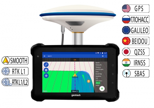
GeoTrack Explorer PLUS is a new development of GeoMeter with EVOLUTION software, which provides parallel driving accuracy at the level of 15 cm from row to row, and the ability to connect to RTK and obtain accuracy of 1-3 cm.
Forget about the loss of satellite signal during work and stopping equipment. With the new and state-of-the-art GM SMART GNSS receiver, your agro navigation system will always be in working order. Thanks to the simultaneous work with satellite systems GPS, GLONASS, GALILEO, BEIDOU, QZSS, IRNSS, you will always have a sufficient number of satellites for full-fledged work in the field. The average number of satellites in operation is over 35 satellites.
GeoTrack Explorer PLUS display has improved technical characteristics, and is ready for stable work for processing large areas.The installation of the Parallel Driving System will allow you to easily solve a number of problems, including: accurate control of equipment in the field, measurement of agricultural areas, complete rejection of signalers and the use of markers, the ability to work with insufficient visibility (at night, in fog, with strong dust content), time saving, a significant reduction in fuel consumption, fertilizers, SPR and herbicides.
Updated functions of the system include visualization and counting of overlaps in real time, quality control of work performance and the possibility of online synchronization of fields and work with the office (Agroprofile www.agroprofile.com system).
FEATURES OF THE GEOTRACK SYSTEM WITH GM SMART RECEIVER:
| Coordinate smoothing mode, which is specially designed for parallel driving systems. Accuracy on a free signal at 15 cm. Stable accuracy at no additional cost. | |
| If you use a GNSS RTK Base Station that transmits satellite signal corrections within 8 km, the GM SMART receiver can operate in RTK mode with an accuracy of 2.5 cm. A base station is required. | |
| There is support for software unlock up to the level of a dual-frequency RTK receiver. The ability to work from GNSS RTK corrections network with a distance of 50 km from the base station with an accuracy of 2.5 cm. |
The new intuitive menu makes working with the device much easier.
GeoTrack Explorer PLUS has a screen with a diagonal of 7 inches (17.8 cm), with enhanced brightness, which reads well even on a bright sunny day. High screen resolution allows you to see a clearer picture. A eye-friendly night vision is provided. The display has impact protection, and is protected from dust and moisture. The set includes a reliable vibration-resistant metal RAM mount and a proprietary dock for maximum comfort. The available connectors RS232 for connecting external devices, such as auto steer and sprayer section control module.
CHARACTERISTICS:
Display: 7 inches (17.8 cm)
Case: strong plastic, metal, tempered glass
GPS receiver: external GM SMART with antenna
Number of channels: 335
Parallel driving accuracy: 15 cm
Parallel driving accuracy from RTK: 1-3 cm
Port: USB type-C
Connector: RS232
Built-in memory: 16 GB
Memory Card:micro SD
Communication Standard Support: 2G/3G/4G
Attachment: RAM (USA)
STRENGTH CHARACTERISTICS:
-
Environmental rating: IP67
-
Vibration test: MIL-STD-810G
-
Gravity drop resistance test: 150 cm
FUNCTIONS:
- Accurate parallel driving
- Accurate area measurement
- Processing Saved Fields
- Counting of processed areas
- Determination of % overlap
- Switching off sprayer sections by overlap
- Shading of treated area
- Display the speed of motion
- Azimuth Display
- Five driving patterns
- Setting the working width (up to centimeters)
- Help directly in the field (connect to the device online)
- Save Field Map
- Save Work
- Specify type of work (sowing, spraying, etc.)
- Online synchronization with Agroprofile
NEW OPPORTUNITIES:
- More modes for parallel driving
- RTK Signal Support
- Synchronize fields and work on Wi-Fi with the online system Agroprofile
- Synchronization by 3G/4G/LTE with the online system Agroprofile
- Displaying Work on a Map
- Online work monitoring (update every 16 seconds, provided that mobile Internet is available) - 12 months free of charge, then (option) 60 y.e./year
- Work planning together with Agroprofile
- Division selection (for large enterprises and holdings)
- Execution of scheduled works from the list of works
- Performance with centimetre accuracy (+ connection to base station)
- Automatic disconnection of option sections (option)
- Auto-check connection (option)
OPERATING MODES:
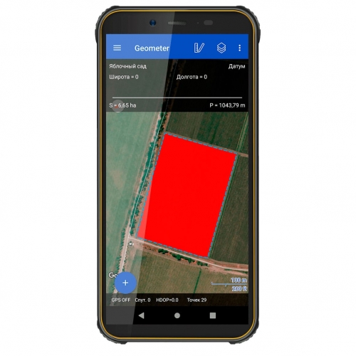
Measuring Field Area
Measure the area of offset fields
Arbitrary
Direct AB
Curve AB
Perimeter-Straight AB
Perimeter-Curve AB
DURING MOVEMENT DISPLAY DATA:
- Processed Area
- Total length
- Speed of movement
- Number of satellites
- Quality of satellite signal (HDOP)
- Visual Control Tips
- Calculation of overlaps
- Visualization of overlaps in a different color
- Ratio: work done / work remaining
- Ratio: treated area/slab area
Driving mode 2D/3D
Day/Night Mode
- manual switching
- automatic switching at a given time
Work planning (can be used as desired):
In the personal account, the Agroprofile is assigned work, which on the specified day is automatically displayed in the section "View work":
- "New Work"
- "Section of works sent for recall"
- "Section of fully completed works".
ADDITIONALLY:
- Official Product Page
- Free online system Agroprofile
- Learn more about Agroprofile
- Display 7 inches (17.8 cm)
- Display protection Dust and moisture (IP68)
- Accuracy 15-20 cm


