RTK subscription for geodesy for 6 months

Basic package for operation in GNSS network in real time (RTK) for 6 months. Includes operation functions from a single base station - "nearest" and network solutions - Automax, I-Max, VRS.
GeoMeter Ukraine offers you the possibility to connect to the RTK signal from the network of base stations. This will allow you to carry out geodetic work with the maximum permissible accuracy up to 2 cm while maintaining accurate coordinates. This is an effective and at the same time flexible solution, because you can subscribe for different periods: for three months, six months or a year.
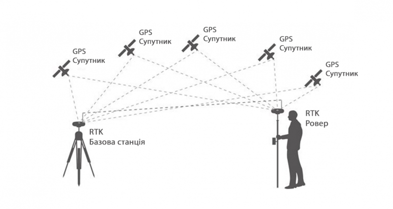
"RTK" is a specially created service that allows you to work with the GNSS receiver GM PRO RTK Rover L1 in the network of base stations instead of creating your own base. More than 120 permanent reference base stations have been installed on the territory of Ukraine, which are combined into a System.NET network. The server transmits RTK corrections to the RTK receiver over the GSM network, which allows achieving accuracy of up to 2 cm during geodetic work anywhere in Ukraine.
Connection to the network is paid, but sometimes it is more convenient than investing in setting up and supporting your own base station.
How does the AgroRTK work?
Pre-location
GNSS tractor receiver determines the approximate position on the ground. Permanent Base Station Network - automatically calculates the nearest RTK stations.
Data processing
The software on the server forms a cluster of several nearest base stations to the tractor.
Exact coordinates
The server transmits RTK corrections to the tractor receiver via the GSM network, which allows to achieve accuracy up to 2 cm in the process of performing agricultural works anywhere in Ukraine.
Benefits of using AgroRTK:
- Maximum accuracy +/- 2 cm. This means that your floors will be reduced to 0.33% on all machine passes.
- Positioning is possible throughout the coverage area of the mobile network, where there is a GSM/GPRS signal and in places with the ability to connect to the Internet using other communication channels.
- High-quality signal reception even in the presence of interference on the ground.
- Reduction in equipment costs. You do not need to install your own base stations for operation.
- Stable accuracy of the result obtained throughout the coverage area, practically independent of the distance to the base station.
- Capacity of the service in case of failure of a single base station.
- Quality control of the obtained measurement result.
- Technical support of field works process.
- Тип Geodesy