
Одночастотний GNSS комплект GM PRO S KIT


Одночастотний GNSS комплект GM PRO S KIT
- Готівкою при отриманні
- Безготівковий переказ
- Приват 24
- Самовивіз з Нової пошти
- Кур'єр Нової Пошти
- Самовивіз з магазину
- Інші транспортні служби
Одночастотний комплект з дециметровою точністю на безкоштовному супутниковому сигналі і з можливістю отримання точності RTK L1. Нова серія приймачів у компактному корпусі GM PRO mini. Комплект складається із захищеного смартфона із встановленим фірмовим програмним забезпеченням geometer SCOUT та GNSS приймача "GM PRO model S" з аксесуарами. Зв'язок з контролером здійснюється за допомогою бездротового Bluetooth з'єднання. Комплект поставляється в герметичній протиударній валізі.
Це оптимальний комплект для точних робіт з площею полів (вимір площі, відстаней і винесення точок). Зовнішній приймач "GM PRO S" використовується для збільшення точності, та поліпшення чутливості і якості GPS/GNSS сигналу. Можна самостійно і з високою точністю здійснювати професійний вимір площі полів будь-якої форми, вимір відстаней, винесення в натуру, межування, вирізання непродуктивних ділянок, створювати електронні карти і багато інших операцій з площею.
Серія приймачів GM PRO mini
Приймач "GM PRO S" має 335 каналів зв'язку з супутниками та працює з більшістю супутникових систем та частот:
- GPS: L1 C/A
- GLONASS: L1 C/A, L1P
- Galileo: E1
- BeiDou: B1
- QZSS: L1C
GNSS приймач "GM PRO S" може працювати в режимі згладжування координат на безкоштовному супутниковому сигналі. Режим згладжування координат - це технологія фільтрації супутникових сигналів, та інтелектуальна адаптація програмного забезпечення приймача при роботі з сигналами L1, яка дозволяє отримувати більш точні координати відносної точності. Детальніше про DP-Filter у документі.
Приймач "GM PRO S" має дуже точно відкалібровану антену геодезичного класу. GNSS приймач "GM PRO S" може працювати з сантиметровою точністю від будь-якої базової станції або мережі поправок через Інтернет (протоколи RTCM 2.X, 3.X, CMR, CMR+). Віддаленість базової станції для RTK версії L1 може бути між 5-8 км. Така доступність базових станцій є у великих містах. Є підтримка програмного розблокування до рівня двочастотного приймача RTK L1/L2 (додаткова опція), що дозволяє використовувати даний приймач з базового рівня точності до професійного. Віддаленість від базової станції під час роботи з двочастотним RTK може становити 50 км і більше. Приймач має вбудований Bluetooth для з'єднання з будь-якими сумісними програмами.
КОМПЛЕКТАЦІЯ:
- GNSS приймач GM PRO S L1
- Захищений смартфон, пам'ять: 6/128 Гб
- Програмне забезпечення geometer
- Кабель живлення для приймача
- Телескопічна віха TS180
- Кейс для зберігання та транспортування
- Кріплення на віху для смартфона металеве
ФУНКЦІЇ
- Межування
- Вимірювання маленьких ділянок
- Прив'язка точок до місцевості
- Вихід на точку
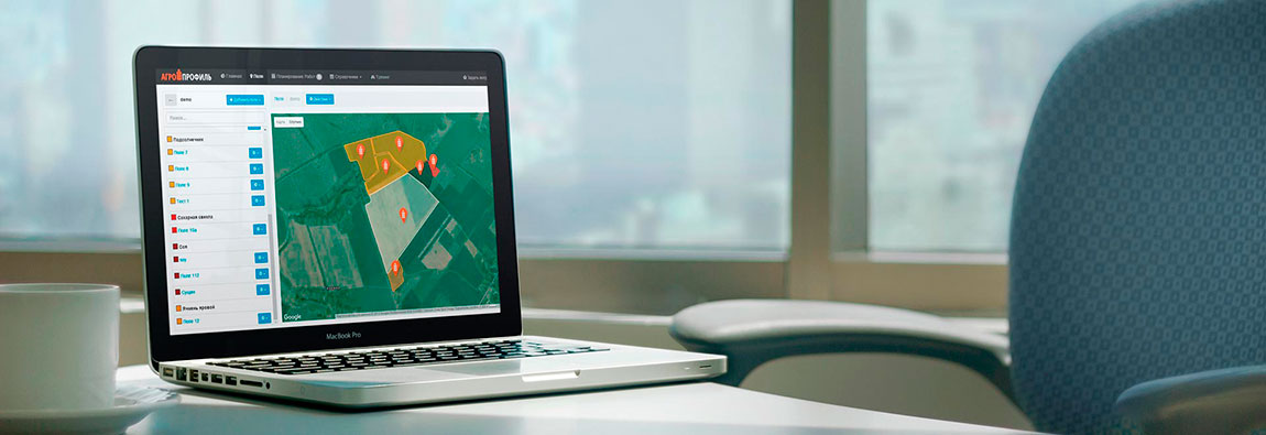
- Створення карти полів
- Робота з кадастром
- Моментальне відображення на картах Google
- Підрахунок кількості гонів при роботі з широкозахватною технікою
- Розділення полів
- Вирізання ділянок
- Розмітка поля
- Планування систем кругового зрошення
- Визначення площі
- Визначення відстаней
- Синхронізація з Агропрофіль
Рівень точності виміру площі:
Точність позиціонування в режимі згладжування:
Точність позиціонування в режимі RTK:
Підтримка програм та операційних систем:
Операційна система:
Android
версія 9 та вище
Додаток:
geometer SCOUT
Додатково
- Сторінка продукту geometer SCOUT
- Завантажити інструкцію з використання
- Безкоштовна онлайн система Агропрофіль
ПІДТРИМКА ПРОТОКОЛУ NMEA
GNSS RTK приймач використовує стандартні NMEA повідомлення, гарантує високу сумісність з усіма видами програмного забезпечення, які підтримують функції геолокації. Це забезпечує точне і надійне визначення координат.
МОЖЛИВІСТЬ РОБОТИ ІЗ КАДАСТРОМ
У програмі geometer доданий спеціальний шар "Публічна кадастрова карта України", який дозволить візуально відображати ваше місцезнаходження стосовно кордонів вашої ділянки. Є можливість встановлювати крайні точки з їх збереженням для подальшого виходу на них.
ВИРІШЕННЯ СУПЕРЕЧЛИВИХ ПИТАНЬ ПО ПЛОЩІ
За допомогою Програмного забезпечення geometer ви легко зможете уникнути будь-яких суперечливих ситуацій. Іноді виникають такі питання, коли техніка наймається на обсяг виконаних робіт. Наймач стверджує, що площа його поля дорівнює 12 га, а ви по витраті палива і інших матеріалів відчуваєте, що це не так. У подібній ситуації вам допоможе програма geometer. Досить обійти або об'їхати поле точно по його периметру, і ви відразу побачите малюнок цього поля та його точну площу. А за допомогою порталу Агропрофіль, ви зможете роздрукувати карту поля з повною інформацією про нього.
БЕЗПЕКА ДАНИХ І ЗРУЧНІСТЬ РОБОТИ З КОЛЕГАМИ
Програма geometer персоналізована. Увійдіть до свого облікового запису Агропрофіль і синхронізуйте поля. Обмінюйтеся нотатками та іншими даними з колегами в рамках одного підприємства. Обмін даними відбувається по безпечному протоколу. Ніхто, крім вас не зможе отримати доступ до ваших даних. Ваш обліковий запис Агропрофіль захищений паролем.
РОБОТА З ПЕНЕТРОМЕТРОМ
Програма geometer дозволить підключати ваш пристрій до додаткових приладів за допомогою модуля Bluetooth і отримувати дані від них. При роботі з Цифровим пенетрометром до шляхових точок додаються параметри щільності ґрунту для вимірюваних точок. Результат виводиться на дисплеї вашого приладу у вигляді графіка, а також зберігається для формування звіту. Таким чином, ви можете отримати кольорову карту щільності будь-якого поля на ваш прилад у зручному для розуміння вигляді.
ПЕРЕНЕСЕННЯ ДАНИХ НА ПК І ХМАРНІ ТЕХНОЛОГІЇ
Зберігайте базу даних ваших полів на всіх ваших пристроях і майте захищений доступ до них 24/7 з використанням системи Агропрофіль. Файли виміряних об'єктів ви можете використовувати в будь-яких програмах, завдяки вбудованим можливостям експортування файлів. Ви можете експортувати дані в наступні формати: kml, utm, mgrs, txt, csv, datum користувача.
РОЗДІЛЕННЯ ПОЛІВ
Програмне забезпечення geometer має інтуїтивно зрозуміле меню, а розділити поле на кілька ділянок можна одним з декількох способів. Використовуйте програму з максимальною користю. Потрібно виміряти поле на кілька частин? Для цього досить торкнутися в потрібному місці на екрані. І ділянку буде розділений по потрібним для Вас параметрами. Ви самі визначаєте як ділити поле.
ВСІ ФУНКЦІЇ В ОДНОМУ КЛІКУ
Абсолютно нове програмне забезпечення geometer - одночасно просте і функціональне. Нова логіка програми дозволить виконати безліч функцій і розрахунків усього в один клік. Будь-то вимір площі, розподіл площі на кілька частин, вирізання непродуктивних ділянок - все це ви отримаєте з максимальною зручністю. Нові можливості: розмітка поля по гонам, підбір найбільш зручної траєкторії обробки полів, вбудовування кіл в напівавтоматичному режимі для будівництва систем кругового зрошення, робота в режимі RTK, відображення вимірювань на картах Google в реальному часі.
-
Габаритні розміри (мм):339 x 295 x 152 мм
-
Вага (кг):2.9 кг
-
Країна виробник:Україна
-
Виробник:Геометр
-
Кількість каналів:335
-
Точність позиціонування горизонтальна:20-40 см
-
Супутникові системи:GPS, Galileo, Glonass, Beidou
-
Частота:1-10 Гц
-
Діапазон робочих температур:-40 °C до + 80°C
-
Версія Bluetooth:4.2
-
Холодний старт:< 50 сек
-
Теплий старт:< 45 сек
-
Гарячий старт:< 3 сек
-
Об'єм ОЗП:6 Гб
-
Вбудована пам'ять:128 Гб
-
Джерело живлення:Акумулятор
-
Підтримка стандарту зв'язку:2G/3G/4G
-
Ступінь захисту:IP67

ГеоМетр Power Station це літій-іонний акумулятор в алюмінієвому корпусі з ємністю 3400мАч.
Це корисний аксесуар для GNSS приймачів і приладів ГеоМетр, який дозволить отримати додатковий заряд в польових умовах. ГеоМетр Power Station універсальний у використанні. GeoMeter Power Station стане в нагоді кожному користувачеві приладів ГеоМетр.

Програмне забезпечення SurPAD 4.2 для Андроїд - це бюджетне рішення, яке дозволить вам здійснювати професійні геодезичні послуги, виконувати роботи з точками, вимірювання відстаней, створення електронних карт, вихід на точку, межування.

Мобільний додаток geotrack - це недорога програма агронавігації для пристроїв Android, яка підтримує всі польові роботи, пов’язані з трактором, такі як обприскування, внесення добрив, збирання врожаю та посів. Разом із програмним забезпеченням користувачі geotrack можуть придбати високоточні рішення GNSS та RTK, які забезпечують згладжену навігацію та сантиметрову точність.