Geotrack App with GM Spike receiver (tractor GPS navigation, agricultural guidance, parallel driving)
")

BUDGET SOLUTION FOR PARALLEL DRIVING
Geotrack evo software with GM Spike receiver for your tablet is a budget solution that lets you create your own parallel driving system for precise control of the wide-reach implement during field operations such as spraying, fertilizing and crop protection. This kit is ready to install on your mobile device, and has an external GPS receiver of basic accuracy.
As a monitor, you can use your tablet or smartphone with Android OS, on which geotrack evo software will be installed. This software includes technical support directly from the developer. In addition, the program is regularly improved and updated in accordance with the needs of modern farmers. If necessary, you can update your program to the latest version yourself. The receiver is connected to your device using a wireless Bluetooth connection or USB (optional). Such a kit will be useful for those types of work where high accuracy is important.

To install the software, you will need a device with the following technical parameters:
| operating system | Android, version 9 and higher |
| Google services | required (Google Maps, Play Market) |
| Screen diagonal | 7 inches or higher |
| RAM | 2 GB or higher |
| Bluetooth | Yes |
| Wi-Fi | Yes (if Agroprofile reports are needed) |
| Sim card | if you need online tracking |
During operation, the system outputs information on the screen for accurate control of the machinery, records the path of the vehicle in the form of a track and accurately calculates the processed area. Thanks to the geotrack evo program, it will be convenient and easy to work with this kit. All control is performed by a single touch to the screen. The program has an intuitive menu, so it does not require special training of the machine operator.

Synchronization of fields and works on the Wi-Fi/3G/4G/LTE with the portal Agroprofile www.agroprofile.com will greatly facilitate the work with the device and provide the possibility of remote control by the manager of workers in the field.
Using the geotrack evo program will allow you to accurately manage agricultural machinery in the field in conditions of poor visibility - at night, in fog, in conditions of heavy dust.


FUNCTIONS
- Accurate parallel driving
- Accurate area measurement
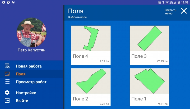
- Processing Saved Fields
- Define Treated Area
- Shading of treated area
- Display the speed of motion
- Azimuth Display
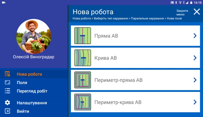
- Five driving patterns
- Adjust grip width (up to centimeters)
- Help directly in the field (connect to the device online)
- Save Field Map
- Save Work
- Specify type of work (sowing, spraying, etc.)
- Online connection with Agroprofile
VIDEO DEMONSTRATION OF THE PROGRAM IN OPERATION:
NEW FUNCTIONS
- Precise parallel driving
- Accurate area measurement
- Processing stored fields
- Determination of the treated area
- Painting the treated area
- Display of driving speed
- Azimuth display
- Five driving patterns
- Setting the working width (up to centimeters)
- Help right in the field (connect to device online)
- Save Field Map
- Saving works
- Indication of the type of work (sowing, spraying, etc.)
- Online communication with Agroprofile

OPERATING MODES:
- More modes for parallel driving
- Synchronization via Wi-Fi with the Agroprofile online system
- Synchronization over 3G / 4G / LTE with Agroprofile online system
- Online control of work execution (updates on the server every 5 minutes, provided that mobile Internet is available)
- Work planning with Agroprofile
- Choosing the type of work
- Selecting a division (for large enterprises and holdings)
- Execution of works on schedule from the list of works
DURING MOVEMENT DISPLAYS DATA:
- Processed Area
- Total length
- Speed of movement
- Number of satellites
- Quality of satellite signal (HDOP)
- Visual Control Tips
- Running Time Count
- Slab Count
- Rendering the slab in a different color
- Ratio: Work Completed/Work Balance
Driving mode 2D/3D
Day/Night Mode
- manual switching
- automatic switching at specified time
Work planning (optional):
In the personal account of Agroprofile, the work is assigned, which on the specified day is automatically displayed in the section "View work":
- "New Work"
- "Section of works sent for recall"
- "Complete Work Section."
ADDITIONALLY
- Free online system Agroprofile
- Learn more about Agroprofile
QUALITY CONTROL OF WORKS
The new GeoTrack software has many functions for determining the quality of work: displaying the processed area, highlighting overlaps in darker color, counting % of overlaps. The system automatically captures the quality of field processing in real time. Now you will know exactly how well the field has been processed.
FULL SYNCHRONIZATION WITH THE OFFICE
With the help of wireless data transmission, the geotrack explorer system can be constantly in communication with the online office Agroprofile. The manager or accountant will be able to monitor progress in real time. The entire eco-system from GeoMeter company allows you to change the quality of preparation and performance of work for the better.

FUEL ECONOMY
Accurate parallel driving between the rows will not allow you to return to the covered areas for their refinement. The processing of the field for you will become controlled and more accurate.
SAVING TIME AND MONEY
The GeoTrack parallel driving system is capable of working at any time of the day, in any weather, in conditions of fog, dust and poor visibility.
SAVING HERBICIDES AND SOWING MATERIALS
The GeoTrack guidance system will allow you to accurately control the machinery between rows, which in turn will allow you to correctly and economically distribute herbicides, sowing materials and other resources during field work.
MAXIMUM POSSIBILITIES WITH AGROFILE SYSTEM
The free online system Agroprofile will complement the functionality of GeoMeter and GeoTrack navigation instruments with a full-fledged agricultural planner, the opportunity to get extended information about each field, including weather for each site, field processing history and many others. Accounting, control, planning and analysis of the efficiency of business processes - with all these tasks will help to cope with the online system Agroprofile.

- Country of manufacture Ukraine
- Synchronization with Agroprofile automatic


